|
Hummingbird Banding Data
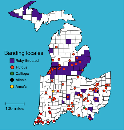
Hummer Hosts have allowed banding to be conducted on their property are indicated on the map below. Clicking on a dot or region links you to the details about that location (i.e., latitude & longitude) and a complete listing of the hummingbirds banded at that site, along with re-encounter data where applicable. Although locations have been pinpointed with GPS to the nearest degree, minute, second, and 1/10 second (00° 00'00.0") of latitude and longitude, they are listed here only to the nearest minute (00° 00') to protect the privacy of the Hummer Hosts. Also note that complete band numbers have not been provided to prevent unauthorized use of the data. Click here for a 2001 Summary |
| Links
to Great Lakes Banding Sites (click on a region or dot for more
details)
|
|